|
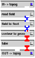
In this network, the topog macro module, shown in Figure 8 has been modified from the original topog module shown in Figure 6. Specifically, this topog module simply provides the contour for the coastline of Australia, without any terrain. This is because this network requires the terrain to be coloured by the (surface) temperature, and so is provided in the main network.
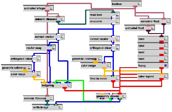
The main network shown in Figure 7 is quite similar in layout to that in Figure 5, however, there are differences in the central region.
The left and right hand edges, as well as the top and bottom regions are essentially
the same, performing the same tasks. The main difference is in the central region.
Here, the temperature is once again extracted with an extract scalar
module, and the lowest slice (in the ![]() direction) is taken with an orthogonal slicer
module. The appropriate colour range for these temperatures is selected with
the color range and generate colormap modules, and then the
temperature field for the surface and this colourmap are fed into the field to mesh
module. The field to mesh module has its
direction) is taken with an orthogonal slicer
module. The appropriate colour range for these temperatures is selected with
the color range and generate colormap modules, and then the
temperature field for the surface and this colourmap are fed into the field to mesh
module. The field to mesh module has its ![]() scale parameter set
to 0, which means that the mesh constructed has the geometry of the underlying
field. This field is irregular, and has the geometry of the terrain of Australia,
and thus the field to mesh module outputs a mesh of the terrain of
Australia coloured by the surface temperature.
scale parameter set
to 0, which means that the mesh constructed has the geometry of the underlying
field. This field is irregular, and has the geometry of the terrain of Australia,
and thus the field to mesh module outputs a mesh of the terrain of
Australia coloured by the surface temperature.